


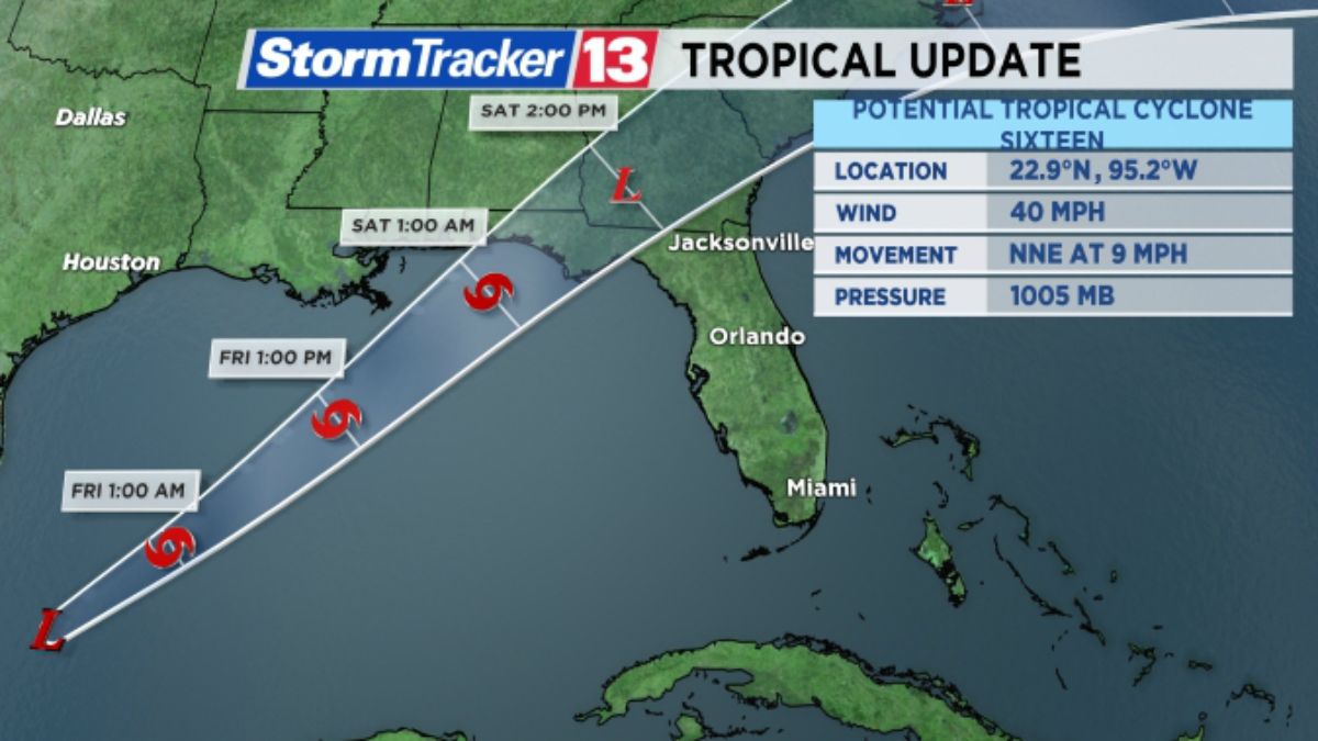
ORLANDO, Fla. — Potential Tropical Cyclone 16 continues to organize in the western Gulf of Mexico this evening and is still on track to become a named storm.
- Potential Tropical Cyclone 16 likely to become Nestor
- Watches, warnings posted for parts of Gulf, west coasts of Florida
- TRACK THE TROPICS: Forecast model tracks, satellite loops, typical tracks per month, and more
- STORM SEASON 2019: Interactive StormTracker | 13 Hurricane Myths Debunked | Printable Supply Checklist | What You Need in Your Hurricane Prep Kit
- WATCH: Why are Rip Currents Dangerous? Certified Meteorologist Chris Gilson Explains
The system is located about 445 miles southwest of the mouth of the Mississippi River.
Winds are now at 40 mph, and the system is moving to the north-northeast at 9 mph.
A potential tropical cyclone is designated when systems are expected to become tropical cyclones and impact land areas within 48 hours.
Sixteen is anticipated to become Nestor early Friday.
A turn toward the northeast is expected, and a faster forward speed is forecast tomorrow into Saturday.
Tropical storm warnings have been extended from from the Aucilla River to Yankeetown.
Storm surge warnings are now in effect from Indian Pass, Florida to Clearwater Beach.
The following advisories are now in effect:
Tropical storm warning for
- Mississippi/Alabama border to Yankeetown Florida
- Grand Isle, Louisiana, to the mouth of the Pearl River
Storm surge warning for
- Indian Pass, Florida to Clearwater, Florida

On its forecast track, this system will make an approach into the Florida Panhandle early Saturday.
Storm surge of 3 to 5 feet will be possible in the Big Bend area, with 2 to 4 feet of storm surge possible along the North Florida gulf coast.
Tropical storm force winds are also expected across the Panhandle and areas of North Florida.
Rainfall of 2 to 4 inches, with isolated 5-inch amounts, will be likely as Nestor moves across northern sections of Florida.
Here in Central Florida, squally weather in anticipated late Friday and will last through the day Saturday. Locally heavy rain, gusty wind, and a few severe storms will be possible.
Stay tuned to The Weather Experts for updates.
Atlantic hurricane season runs through November 30.

- TRACK THE TROPICS: Watches, warnings, forecasts, satellite loops, spaghetti models
- 7-DAY FORECAST: Rain chances, county-by-county temperatures
- NEIGHBORHOOD RADARS: County-by-county radar images
- THEME PARK INCLEMENT WEATHER POLICIES: Major Florida theme parks' hurricane or inclement weather policies in case of cancellations, closures