EDITOR'S NOTE: Multimedia journalist Shellye Leggett looked at how SoCal residents were preparing for this week’s heavy rainfall and what measures Los Angeles County officials said they were taking to prepare. Click the arrow above to watch the video.
LOS ANGELES — A strong storm system moving through Los Angeles and Orange counties Thursday is bringing a heavy dose of rain over a short period of time and prompting evacuation orders, flood warnings and road closures.
What You Need To Know
- Scattered showers moved into Southern California Tuesday and kicked off a series of late-winter storms expected to bring heavier rainfall lingering into Friday
- Officials issued evacuation warnings and "address specific" evacuation orders in places vulnerable to mudslides, including recent burn areas
- A flood watch was expected from Wednesday at 6 p.m. to Thursday 6 p.m.
- In Orange County, officials issued evacuation orders for areas in Trabuco Canyon, Hot Springs Canyon and Bell Canyon effective at 6 p.m., while Long Canyon and Modjeska Canyon remained under voluntary evacuation warning due to possible debris flows along or near the Airport Fire burn scar
"A fast moving cold front will blast through the area overnight with most of the steady rain finished by 8 a.m. Thursday, if not sooner," the National Weather Service said. "Despite the relatively fast speed, the system will pack quite a punch with a 60%-80% chance of hourly and/or sub-hourly rates to exceed debris flow thresholds somewhere in the foothills and mountains and possibly in other areas as well.
"Thursday will be a mixed bag of weather conditions with rapidly lowering snow levels, increasing air mass instability with isolated thunderstorms, as well as periods of no rain and some sunshine," the NWS added. "Rain could be very heavy at times with small hail and snow as low as 2,500-3,000 feet. Travel over some of the mountain passes may not be possible at times and travel delays and closures should be expected."
The rainfall is expected to linger into Friday before clearing up ahead of the weekend.
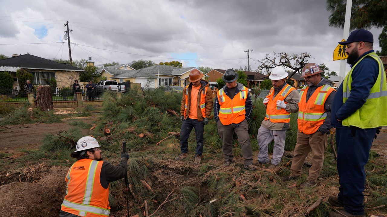
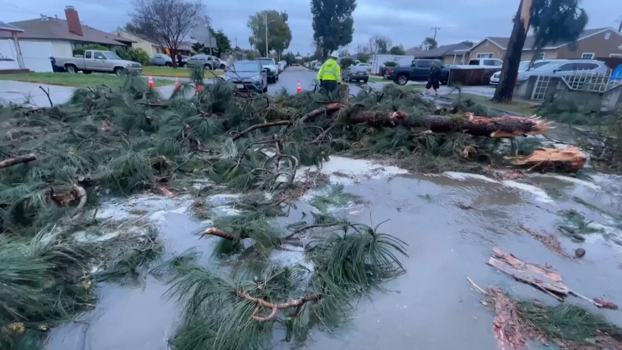
Flooding was reported on Los Angeles area freeways Thursday. Considerable flooding was reported by the California Highway Patrol on the connector road from the westbound Pomona (60) Freeway and the southbound Chino Hills (71) Freeway in Pomona and the connector road from the southbound Harbor (110) Freeway and the eastbound Glen Anderson (105) Freeway.
In El Monte, flooding closed the fourth lane of the westbound San Bernardino (10) Freeway at Peck Road. Wet conditions caused a white Tesla to run off the road at the Lower Azusa Road exit of the southbound San Gabriel River (605) Freeway in Irwindale and a black Toyota Tacoma spun out and crashed into a freeway divider on the westbound Glenn Anderson (105) Freeway at the Long Beach Boulevard exit in Lynwood.
With Los Angeles County facing nearly an inch of rain per hour during the storm's peak, officials issued evacuation warnings and "address specific" evacuation orders in places vulnerable to mudslides, including recent burn areas, the Los Angeles Fire Department announced Tuesday.
The city of Sierra Madre also issued evacuation orders and warnings Wednesday for several areas in the foothills of the San Gabriel Mountains. They can be found here.
All evacuation orders and warnings were in effect from 7 a.m. Wednesday to 6 p.m. Thursday.
Officials said the following burn areas were "especially susceptible to heavy rain":
- Palisades Fire: Getty Villa area, Highlands near the burn areas, Bienveneda area near Temescal Canyon Park, Rivas Canyon/Will Rogers State Park area, Mandeville Canyon above Tanners Road, Old Ranch Road and Rustic Creek
- Sunset Fire: East and south of Runyon Canyon
- Hurst Fire: Olive Lane in the Oakridge Mobile Home Park
- Airport burn scar area in Orange County
Houses in the warning area with high risk were being visited by the Los Angeles Police Department on Tuesday to receive specific evacuation orders. If residents are not home, the department was leaving a flyer with relevant information.
Mayor Karen Bass announced Wednesday morning that Los Angeles' Emergency Operations Center has been activated to a Level 2.
"While we prepare for another storm headed towards LA, I want to urge Angelenos to stay vigilant, especially in burn scar areas," Bass said. "My number one job is to keep Angelenos safe, so please heed all evacuation warnings, stay vigilant and stay informed."
Gov. Gavin Newsom also said officials were prepared for the storm.
"We have hundreds of personnel on the ground across the state ready to help communities prepare for this week's storm. In Altadena and the Palisades, we're continuing our months-long efforts to protect against potential debris flows," Newsom said in a social media post Wednesday.
A flash flood warning was issued for parts of Los Angeles County, including the Palisades and Franklin burn scar areas, until 3:30 a.m. Thursday.
There is a flash food warning in effect for the Airport burn scar in Orange County until 7:30 a.m. Thursday.
A flood watch was issued until 6 p.m Thursday in areas of Los Angeles and Orange County.
Caltrans closed a segment of Pacific Coast Highway to residents and businesses in burn scar areas at noon Wednesday due to safety concerns from the incoming storm. Only emergency vehicles and U.S. Army Corps of Engineers debris- hauling contractors will be allowed through the closure, between Chautauqua Boulevard and Carbon Beach Terrace.
Residents with homes in the burn scar area should consider alternate routes in the afternoon hours or consider teleworking if possible, officials said.
LA Metro officials said bus Line 134 would be canceled at noon Wednesday until further notice.
Caltrans and other officials will reassess the situation Thursday to determine if the highway can reopen to residents and businesses with passes by Friday for morning commute, if not earlier. That decision is dependent on the extent of the storm and resulting impacts of any debris flows.
LA County Public Works crews have prepared debris basins, stabilized slopes, and reinforced drainage systems to reduce flood risk, particularly in recent burn areas including Eaton, Palisades, Bridge, Hurst, Kenneth, Hughes, Sunset, Lidia and Franklin, officials said.
"While these efforts reduce flood risk, the storm could still bring moderate debris and mudflows to burn areas, potentially blocking streets and threatening structures depending on their location and the local terrain," the department said.
"To mitigate potential impacts, LA County Public Works has activated 24/7 storm patrols and remains fully mobilized," officials added.
LA County's Mudflow Advice Hotline can be reached at 800-933-0930, for questions about debris flows.
For storm preparedness tips, the county advised residents to visit here.
Health officials also warned the public to avoid the water at all Los Angeles County beaches due to high levels of bacteria anticipated due to the rain. That warning will be in effect until at least 4 p.m. Friday.
In Orange County, officials issued evacuation warnings for areas in the Trabuco Canyon, Hot Springs Canyon, Bell Canyon, Long Canyon and Modjeska Canyon due to possible debris flows along or near the Airport Fire burn scar.
Long Beach was preparing for potential flooding, particularly in low-lying areas including along the peninsula and Alamitos Bay. The city has activated sandbag distribution sites for all residents through Thursday, with sand and sandbags available at all fire department neighborhood stations.
Rainfall is expected to range from 1 to 2 inches along the coast and in valley areas and 2 to 4 inches in the foothills and mountains. Rainfall rates could reach up to .75 inches per hour.
This system will also likely be the biggest snow maker of the season, with 1 to 2 feet of snow forecast for higher elevations.
Stronger, gusty southwest to west winds will continue through Thursday night, the NWS said.
Cooler temperatures are expected all week, with daytime highs dropping in downtown Los Angeles to around 55 on Thursday and Friday. Overnight lows will generally be in the 40s and lower 50s, but will drop into the 30s on Thursday and Friday in the mountains and the Santa Clarita and Antelope Valley.