Everyone has experienced it. You're in the middle of your flight, and all of a sudden, you feel the plane shake or jolt.
The pilot comes on the intercom and announces you’re experiencing turbulence and to buckle up.
But what exactly is turbulence?
Turbulence is the unsteady movement of air resulting from eddies and vertical currents. There are many types of turbulence. Let’s explore some.
When the sun heats the Earth’s surface, it’s usually uneven because different surface types heat up differently, and this can lead to turbulence.
The heat then rises, and the cool air descends, leading to bumpy rides. According to the National Weather Service (NWS), turbulence is found from the base to the top of where the air stops rising, usually up to the clouds. Above this layer of turbulent air, you’ll find smooth conditions, usually above clouds.
On days where pilots expect convective turbulence, they’ll travel in the morning or evening when heating is not so intense.

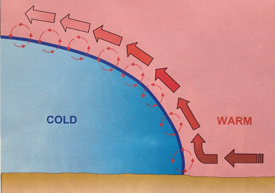
Frontal turbulence occurs when warm air meets cold air.
The warm air will lift over the cold air, creating friction between the two air masses and producing turbulence.
Wind shear is the change in wind direction and/or wind speed over a horizontal or vertical distance. It can also cause turbulence, especially when the change is large.
Wind shear often exists in areas of temperature inversions, along troughs and lows and around jet streams.
The atmospheric temperature profile usually goes from warm (the ground) to cold (higher in the atmosphere). In a temperature inversion, that profile goes from cold to warm.
Turbulence will often occur at the top of the inversion since that is where the warm, unstable air sits.
We usually associate lows and troughs with wind shear. This change in wind speed and direction creates turbulence.
The NWS states that a jet stream is a horizontal wind that follows a wave pattern, usually located where there are large horizontal differences in temperature between warm and cold air masses. Turbulence usually occurs where there is a large difference in horizontal wind speeds over a short distance.
When wind flows around an obstacle, it can break off and form into an eddy. The NWS defines eddies as gusts with sudden changes in speed and direction, and the size of an object and velocity of the wind can determine the eddy's intensity.
The NWS says this type of turbulence can cause dangerous impacts when flying. Aircraft can fail to gain enough altitude to clear low objects. When landing, aircraft can experience drops.
Wind around bigger objects, such as mountains, is more noticeable. The wind moving up the windward side helps planes and other aircraft get over the peak.
But on the leeward side, the wind blowing down can cause problems for pilots. The downdraft can push an aircraft into the mountain or cause the pilot to not clear the peak.
Pilots often will gain enough altitude in advance to prevent this.
I hope this information will help you relax the next time you fly.
If you experience turbulence, you’ll now know that it’s just wind, and your pilot knows how to manage it.
Engineers also designed and built your airplane to handle it.
Our team of meteorologists dives deep into the science of weather and breaks down timely weather data and information. To view more weather and climate stories, check out our weather blogs section.


