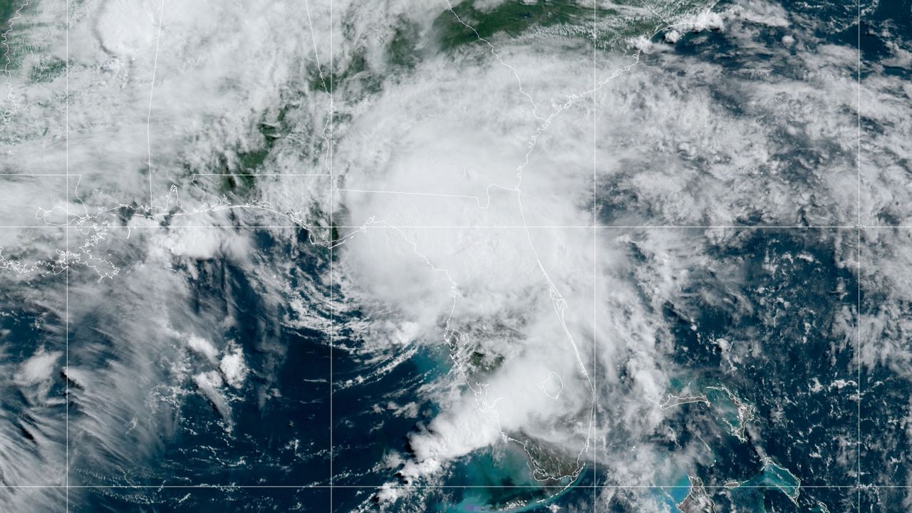
11 a.m. update: Elsa is holding at 65 mph per hour as it makes landfall in Taylor County along the nothern Florida gulf coast.
Here are the changes with this advisory:
- All warnings south of Aripeka, Florida, have been discontinued.
- The hurricane warning along the west coast of Florida has been changed to a Tropical Storm Warning.
- The Storm Surge Watch for the Florida Gulf coast has been discontinued.
- The Tropical Storm Watch has been extended northward along the mid-Atlantic coast to Sandy Hook, New Jersey, including the Chesapeake Bay south of North Beach, the tidal Potomac south of Cobb Island, and Delaware Bay south of Slaughter Beach.
10:00 a.m. update: Flood Watch remains in effect for entire Bay area until 2 p.m.
9:00 a.m. update: Tampa International Airport has resume operations
8 a.m. update: Elsa is continuing to move north at 14 mph with 65 mph winds. Little change in strength is likely until landfall later today.
The Tropical Storm and Storm Surge Warnings have been discontinued south of the Middle of Longboat Key.
On the forecast track, Elsa will make landfall along the north Florida Gulf coast by late this morning or this afternoon. The storm should then move across the southeastern and mid-Atlantic United States through Thursday.
Tropical-storm-force winds extend outward up to 90 miles (150 km) from the center. A C-MAN station at Cedar Key, Florida, recently
measured a sustained wind of 41 mph (66 km/h) gusting to 51 mph (66 km/h).
5 a.m. update: Tropical Storm Elsa is moving north at near 14 mph with wind gusts at 65 mph. A general northward motion is expected to continue through the afternoon as Elsa moves near or over portions of Florida's west coast.
The storm is expected to make landfall along the north Florida Gulf Coast by late this morning or afternoon. Tropical-storm-force winds extend outward up to 90 miles (150 km) from the center. Weakening will begin after Elsa makes landfall.
2:27 a.m. update: The tornado warning mentioned in the last update has expired.
2:10 a.m. update: A tornado warning is in effect until 2:30 a.m. for eastern Sarasota County and small part of southeast Manatee COunty.
1:50 a.m. update: Elsa has been downgraded to a tropical storm after appearing more disorganized over the last few hours. Tornado Watches remain in effect, though, and the potential threat of storm surge in areas along Tampa Bay hasn't gone away.
The storm's center of circulation is currently about 60 miles west of Tampa with maximum sustained winds of 70 mph.
It's moving north at 14 mph.
1:35 a.m. update: The Tornado Warning that was issued for eastern Pasco and Hernando County has been canceled.
1:15 a.m. update: A Tornado Warning has been issued for the Dade City area, including parts of eastern Pasco and Hernando County though 1:30 a.m. If a tornado has touched down, it will be racing to the north at 40 mph.
1:10 a.m. update: TECO is reporting more than 10,500 outages. FPL reporting about 2,200 outages in Manatee County. Duke Energy reporting scattered outages (less than 100) in Pinellas and Pasco counties. | Power Outage Maps | Watch live updates NOW on Spectrum Bay News 9.
11:50 p.m. update: What to know entering Wednesday morning:
- Gusty rain squalls with wind gusts between 35 and 55mph will still be common as Elsa passes by with some gusts in the 60s still possible at the coast.
- A Tornado Watch remains in effect through 8am as there is still a chance for some tornadoes to spin up as the storm passes by.
- A Flood Watch is still in effect as very heavy rain will fall in the heaviest squalls. 2 to 4 inches will be common with some amounts in the 4 to 8 inch range.
- There’s still a storm surge threat mainly for the overnight/early morning high tide, but it will be limited to isolated low-lying areas and we’re lucky that this high tide is not a particularly high one. | Watch live updates NOW on Spectrum Bay News 9.
11:20 p.m. update: In Gulfport, Spectrum Bay News 9 reporter Angie Angers said: "Elsa is definitely here in the form of wind. No major flooding or storm surge issues yet. Businesses are sandbagged and the tide remains low. Really the big headline here is the intense gusts of wind." | Watch live updates NOW on Spectrum Bay News 9.
11 p.m. update: The latest advisory keeps Elsa as a Category 1 Hurricane, but Spectrum Bay News 9 meteorologist Brian McClure said the trend definitely looks weaker all of a sudden. But it might be a little too soon to declare it a permanent trend.
Rain bands with squally weather will still continue through the night. | Watch live updates NOW on Spectrum Bay News 9.
10:38 p.m. update: Heavy rain bands in Manatee and Sarasota counties. Meanwhile, the Tornado Watch for Tampa Bay has been extended to 8 a.m. Wednesday. | Watch live updates NOW on Spectrum Bay News 9.
10:25 p.m. update: Gusts in the 70 mph are looking more unlikely, though gusts in the 30s, 40s and 50s are still expected with rain bands from Elsa. | Watch live updates NOW on Spectrum Bay News 9.
10 p.m. update: Meteorologist Brian McClure said, "We're really happy with the trend we've seen just in the past hour to two hours."
We could still see wind gusts that have been forecasted.
The center of Elsa is moving due north. If it weakens, we wouldn't get the strongest weather, but Brian said that is a trend.
There will still be a 11 p.m. advisory issued for Elsa. | Watch live updates NOW on Spectrum Bay News 9.
9:30 p.m. update: Spectrum Bay News 9 meteorologist Nick Merianos said on Twitter: 'Worst weather with Elsa is offshore and high winds may brush the coast of Pinellas County. Small system so strong winds will mainly remain on the immediate coast."
PREVIOUS
Elsa is once again a hurricane with the 8 p.m. advisory. It is a Category 1 hurricane with sustained winds of 75 p.m.
A Tornado Watch has been issued for a number of Central and South Florida counties, including Hillsborough, Pinellas, Polk and Manatee in the Tampa Bay area.
What You Need To Know
- Watch Live Updates now on Spectrum Bay News 9
- Tropical Storm Elsa winds at 75 mph at 8 pm advisory
- Elsa strengthened a little this afternoon in spite of marginal atmospheric conditions
- Worst weather is to the east of the center
- LIVE UPDATES: Spectrum Bay News 9 meteorologists, reporters have latest on Elsa
The watch, which also includes multiple South Florida counties, is in effect until 11 p.m.
Elsa strengthened a little this afternoon in spite of marginal atmospheric conditions.
This is still a highly sheared system with most of the worst weather to the east of the center.
Expect high end tropical storm force winds and heavy rain this evening, gradually ending overnight. The risk of storm surge will be after the winds shift into the west, or onshore, probably after midnight.
A surge of 2-4 feet is likely with some areas possibly getting more water on the Nature Coast late tonight.
A Hurricane Warning is issued for the coast from Tampa Bay northward into the Big Bend.
Elsa could make landfall tonight as a category 1 hurricane. The highest winds appear to be limited to a fairly small area to the east of the center. The overall wind field is not large.

Widespread tropical storm force winds are expected in the Tampa Bay area and up the Nature Coast with some hurricane force winds possible on the immediate coast.
A Tornado Watch has been issued for the area generally south of I-4 through 11 pm.
The wind will increase tonight.
There will be a chance for a few tornadoes today and tonight. The timing of the worst of the weather for the Tampa Bay Area is still not entirely certain, but looks to be between 6 pm tonight and overnight tonight.

Summary of watches and warnings at 5 p.m. Tuesday
CHANGES WITH THIS ADVISORY:
A Tropical Storm Warning has been issued for the coast of Georgia from the Mouth of St. Marys River to Altamaha Sound.
The Tropical Storm Warning for the Florida Keys east of the Seven Mile Bridge has been discontinued.
SUMMARY OF WATCHES AND WARNINGS IN EFFECT:
A Storm Surge Warning is in effect for...
* West coast of Florida from Bonita Beach to the Aucilla River, including Tampa Bay
A Hurricane Warning is in effect for...
* Egmont Key to the Steinhatchee River, Florida
A Tropical Storm Warning is in effect for...
* The Florida Keys from the Seven Mile Bridge westward to the Dry Tortugas
* West coast of Florida from Flamingo to south of Egmont Key
* West coast of Florida north of Steinhatchee River to Ochlockonee River
* Coast of Georgia from the Mouth of the St. Marys River to Altamaha Sound
A Storm Surge Watch is in effect for...
* West of the Aucilla River to the Ochlockonee River, Florida
A Tropical Storm Watch is in effect for...
* North of Altamaha Sound, Georgia, to South Santee River, South Carolina


