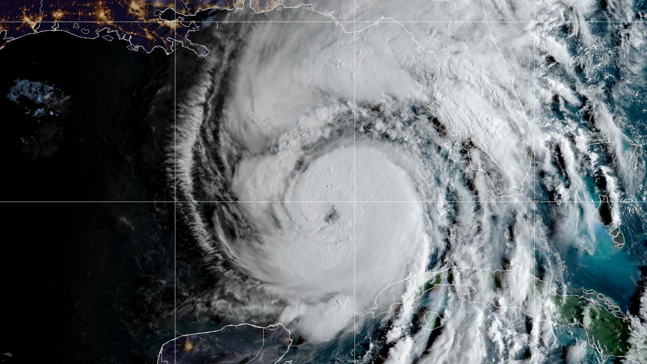
Summer is over, and it is now October. But, the weather has been unusually warm around the Tampa Bay Area. In most locations around the Tampa Bay Area, September 2018 was the warmest or top three warmest on record for hot Septembers.
But, the numbers specifically for Tampa do seem a little off. Tampa during September saw an average temperature of 85.9 degrees. That was 4.2 degrees above normal.
Some other spots around West Central Florida were also very warm but nowhere close to Tampa’s results. St. Pete averaged 84.4, Clearwater 83.8, Lakeland 83.8, Ruskin (where the National Weather Service office is located) averaged 83.0 and Bradenton (SRQ Airport) averaged 82.6.
So, the closest in temperature to Tampa was 1.5 degrees cooler averaged over the whole month.
Our staff of meteorologists here at Spectrum Bay News 9 began noticing some oddities with the weather reported in Tampa in the early 2000s.
Most of us have been here for 15-21 years so we have a long history in carefully watching the official temperatures and conditions at Tampa International. This is a crucial aspect of our forecast and verification. When we noticed things seem a bit off, we continue to follow it.
Some of the warmest temperatures EVER recorded in Tampa occurred during September 2018. Not June, not July, not August, not during drought years, but September 2018, when Tampa officially had 50% more rainfall than normal.
Despite rain-cooled weather, it was still so hot. Over the last few years, we noticed an increase in temperatures at Tampa International Airport during situations where other sites around the region were much cooler.
During the mornings, for example, T.I.A. just wouldn’t cool off. We often think of a night with light or calm wind and clear skies as an opportunity for some cooling to take place.
Now, in the summer, it doesn’t cool that much, but the last two weeks of September had temperatures for lows in Tampa average 5-8 degrees above average despite weather conditions that would favor otherwise.
We have seen during the winter, during what we consider an ideal cooling setup, Tampa’s temperatures stay 5-10 degrees above freezing, whereas other places easily drop below 32 degrees.
And, I am talking about locations close to Tampa and some areas with water nearby. MacDill Air Force Base has an observation, that during the winter time, can easily read 5-6 degrees colder in the mornings.
Just this past weekend, Tampa officially broke record highs 2 days in a row with unbelievable readings of 97 degrees! On Saturday, the closest official observation elsewhere was 95 (most spots were 92-93) and on Sunday, when Tampa hit 97 again, most locations were about 90-92! That is a 5+ degree difference!
Tampa’s official sensor is at Tampa International Airport. It is at the south end of the runway on the west side of the airport. The sensor’s location is surrounded by highways that have been expanded over the last half dozen years.
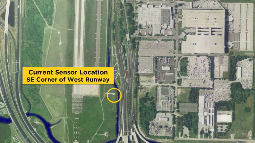
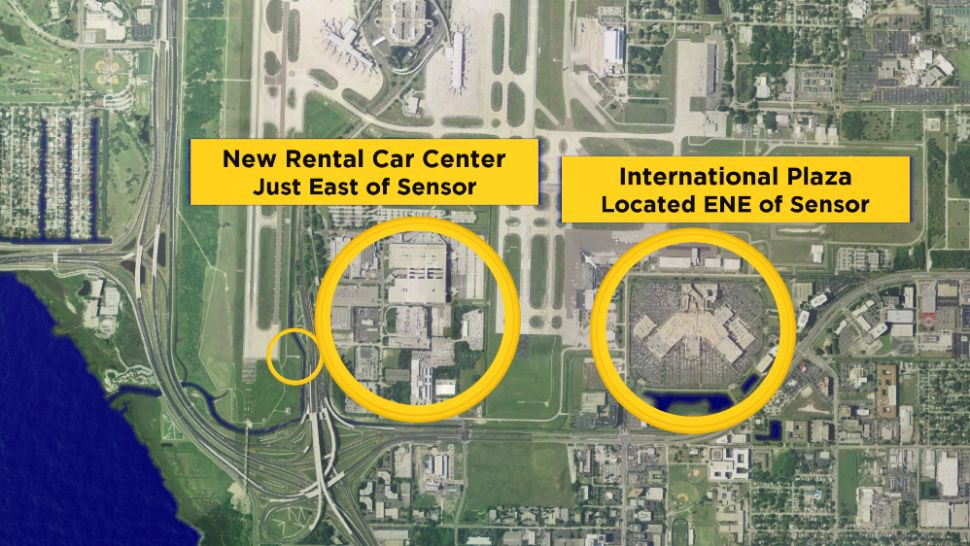
To the east of the sensor is the newly built rental car center, that 2-3 years ago was a nice open field. And just to the east of that is International Plaza, which in the 1990s was also a nice open field.
These two locations, located just to the east of the sensor, prevent cooling at night at the sensor when we have a light prevailing east wind. That is the wind flow we have about 75% of the time during the summer months. A light ENE or NE wind is optimal for cooling during the night in the winter. But, it just isn’t being recorded that way any longer.
The problem is known as the "heat island" effect. Now, this is more common in big cities and can be an issue with respect to energy costs and usage for example.
Heat islands form as vegetation is replaced by asphalt and concrete for roads, buildings and other structures necessary to accommodate growing populations.
These surfaces absorb—rather than reflect—the sun's heat, causing surface temperatures and overall ambient temperatures to rise. Displacing trees and vegetation minimizes the natural cooling effects of shading and evaporation of water from the soil.
This effect is most notable during calm, clear evenings. This is because areas without concrete and with more vegetation cool off faster at night than Tampa International Airport, for example, which retains much of the heat stored in roads, buildings and other structures.
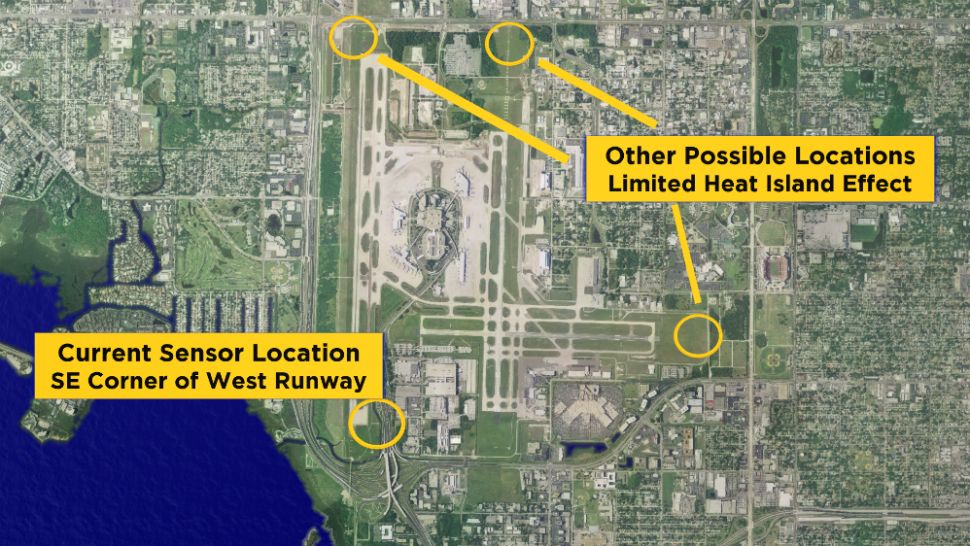
There are better locations for the sensor if it is to be kept on the airport property. I have indicated them on the map below with a yellow "X." These are locations that have less of a chance of being influenced by the heat island effect. They are more removed from highway traffic and large parking lots and buildings.
An ideal location for the official sensor for Tampa would NOT be at the airport at all. But, if it had to stay, these spots would be better.
We have also noticed wide swings in the temperatures over just a few minutes during the afternoons. This past week, we saw temperatures fluctuate 3-7 degrees over 5-10 minute time frames.
After communicating with some people with the National Weather Service, it has been determined that the sensor at Tampa International Airport has been calibrated properly.
This is good, however, troubling at the same time, as these temperature extremes are not representative of the rest of the area.
During the past week, we examined a collection of temperatures around the area. Both official and unofficial observations have their data posted online. Now, some of these observations aren’t necessarily reliable, but there are dozens of them within a few miles of Tampa International Airport.
On Saturday, we found 2 locations that were within 3 degrees of Tampa International Airport. On Sunday, the closest temperature was 92. That was 5 degrees off from the official observation.
In general, there are many problems with having an "official" observation so far off from the reality of the area. It makes forecasting difficult.
Are we supposed to forecast for the airport’s bad sensor location or for what our viewers experience? This is most crucial in the winter. I don’t want to forecast 38 when I believe there will be a freeze. That doesn’t help people prepare.
I don’t want to have to explain why the "official" temperature is so far off from what people in the area experience. It also skews record keeping, and over time would change the "normal" temperature of the area.
People often ask us why do we report the temperature at the airport. The simple answer is because that is where the sensor is located. But, these sensors were never really meant for temperatures anyway. They were predominantly used for aviation. So, their main purpose is wind and visibility.
I feel it is time, that if we are going to use observations for official records, that they accurately reflect Tampa’s climate.


