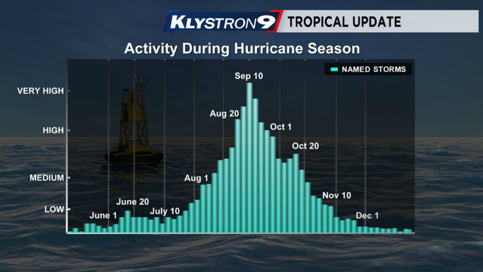
Hurricane Season is six months long — half the year from June 1 through November 30. The statistical peak of the season is between September 10-14.
- Statistical peak of hurricane season has come and gone
- Uptick in October referred to as secondary peak
- More blogs from Spectrum Bay News 9 Weather Experts
- 2019 Storm Season headlines, tips
So, now that we have passed that, what does that mean? Well, historically, we see a marked decrease in the number of named storms as we get later in the season. Parts of the basin, climatologically and historically, begin to shut down due to other weather events like cold fronts, dry air, cooler water temperatures, etc.
But, you may notice on the graph that there is a little uptick in October. That is often referred to as the secondary peak. That is also the time, when historically, we would have our highest likelihood of a Gulf of Mexico tropical storm or hurricane. There actually is a good reason for this.
Historically, hurricanes in September form from tropical waves moving westward across the Atlantic from Africa. If they take a far enough south track, they make it into the Caribbean. During the middle of the summer, there aren’t as many weather systems across the United States that "pick them up" and move them northward.
But, as we get later in the year, there is a higher likelihood of having cold fronts influence the track of Caribbean hurricanes and draw them northward into the Gulf of Mexico. Most recently we think of Hurricane Michael in 2018. Michael wasn’t a long tracker across the Atlantic but its parent tropical wave was. It didn't develop until it made it into the Western Caribbean. Then, a cold front pulled it northward through the Gulf of Mexico.
Other notable storms that formed like this are Wilma in 2005, Mitch in 1998, Opal in 1995, The Cuba-Florida Hurricane of 1994 that hit Tampa Bay. Of course there was also the Tampa Bay Hurricane of 1921, and countless others going back into the 1800s.
Then, once we move beyond October, even though there is still one more month to go, we end up with a much lower chance of West Coast Florida tropical activity, mainly because by that time, many cold fronts have moved through the area and the water has cooled a bit, and the atmosphere just isn't conducive for development this far north too much more.


