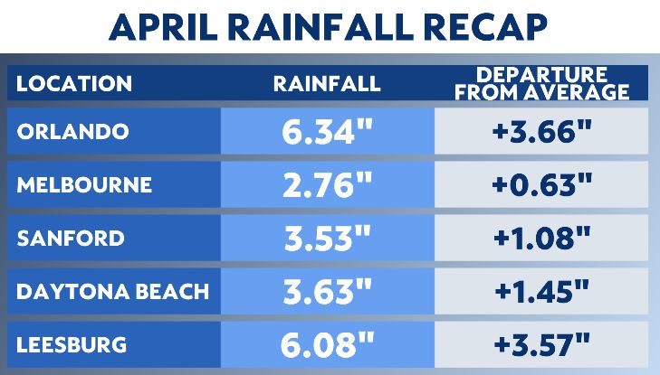
Central Florida went into April with large rainfall deficits, but a few weekends of heavy rain led to many spots with a significant rainfall surplus by the end of the month.
Typically, April is the fifth driest month for Orlando. The average rainfall is 2.68 inches, but this April, Orlando picked up more than six inches of rain.
Orlando experienced its sixth wettest April on record, while it was Leesburg's fifth rainiest on record.
Orlando and Leesburg finished with more than a 3.50-inch rainfall surplus. The driest spot was Melbourne, which finished just shy of three inches of rain for the month.
Several late-season cold fronts were responsible for the wetter-than-average conditions across Central Florida.

The rainy setup and late-season fronts also led to temperatures finishing close to average.
Temperatures were only around a half degree warmer than normal for Orlando, Daytona Beach and Leesburg.
Sanford finished at almost average, while Melbourne was the warmest for the month. Their temperatures were nearly two degrees warmer than normal.
As we turn the calendar over to May, get ready for hotter temperatures, higher humidity and the possible onset of the rainy season by the end of May.
The average start date of the rainy season is May 24. This is generally when low temperatures do not drop below 70 degrees, the humidity stays high and we start to see daily rounds of showers and thunderstorms.
May 25 is when Orlando's average high hits 90 degrees after starting the month at 85 degrees. The normal high for Orlando does not dip below 90 again until September 18.
Orlando's average high peaks at 92 degrees from July 7 through August 20.
So, get ready for more heat and humidity as we roll through May.


