The National Hurricane Center (NHC) will experiment with some tweaks to the way the cone of uncertainty is presented this hurricane season.
Instead of just displaying watches and warnings at the coast, the NHC will distribute display all tropical watches and warnings through inland areas in a new graphic on their website.
“The absence of displaying those warnings inadvertently gives the impression that it’s all clear in the more inland locations,” says Deputy Director of the National Hurricane Center, Jamie Rhome.
Here is a look at what the new experimental cone will look like.

For reference, here is what the traditional cone of uncertainty looks like.

Studies have shown that it is common for people to misinterpret the cone of uncertainty.
For instance, according to a study by Colorado State University, people perceive the widening of the cone toward the end of the forecast period to mean that the storm will be getting bigger.
In reality, widening the cone is just communicating a greater degree of uncertainty as to where the center of the storm will pass. It is independent of the size or intensity of the storm.
The NHC hopes to reduce misinterpretation with a new look to the cone, and this new experimental graphic is a step in that direction.
“I suspect we will have to make other changes in the realm of hurricane risk communication as time marches on,” says Rhome. “we want to move people off the cone and onto the hazards.”
Other changes could come to the cone in the future, but the National Hurricane Center wants feedback from professionals and the public before going any further.
“That’s what this experimentation is about, to start a discussion and open up a forum and a venue for people to talk to us about what changes need to be made in hurricane risk communication,” says Rhome.
Even with slight changes to how the cone is displayed, the meaning of the cone of uncertainty, along with tropical watches and warnings, will not change.
The traditional, operational cone of uncertainty will continue to be distributed by the NHC. The new, experimental, graphic will be available on the National Hurricane Center Website.
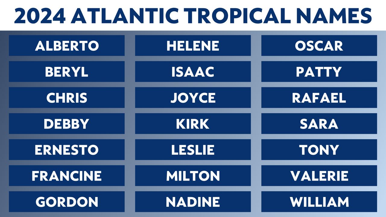
Here’s a look at the list of names for the 2024 Atlantic Hurricane Season.

Our team of meteorologists dives deep into the science of weather and breaks down timely weather data and information. To view more weather and climate stories, check out our weather blogs section.


