ST. PETERSBURG, Fla. — This story is no longer being updated. Click here for the most recent information on Helene.
***
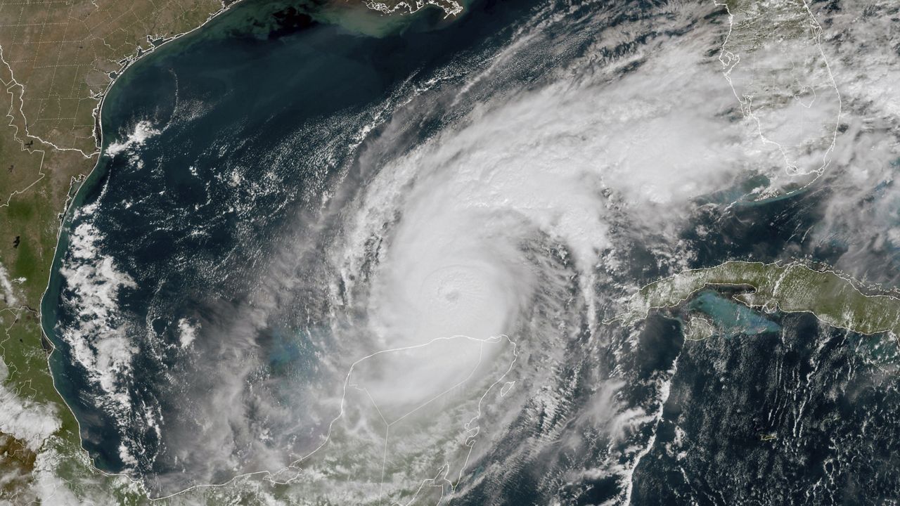
Hurricane Helene continues to intesify ahead of landfall, it is currently Category 4 storm with maximum sustained winds of 140 mph.
It is swiftly moving north-northeast in the Gulf of Mexico at 24 mph.
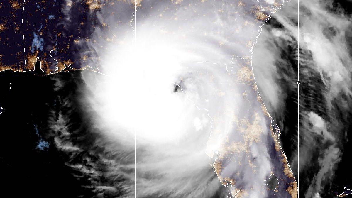
It’s expected to be a major hurricane in the eastern Gulf today with landfall in the Florida Big Bend tonight with a life-threatening storm surge.
Storm surge could be as high as 4 to 7 feet in Tampa Bay and 6 to 15 feet in Levy, Citrus and Hernando counties.
The surge will increase later through the night. Water levels could be some of the highest we’ve seen in many years from the Nature Coast northward.
There is a Tornado Watch in effect for Florida peninsula until 6 a.m. It includes all of our area and including the east coast of Florida and South Florida.
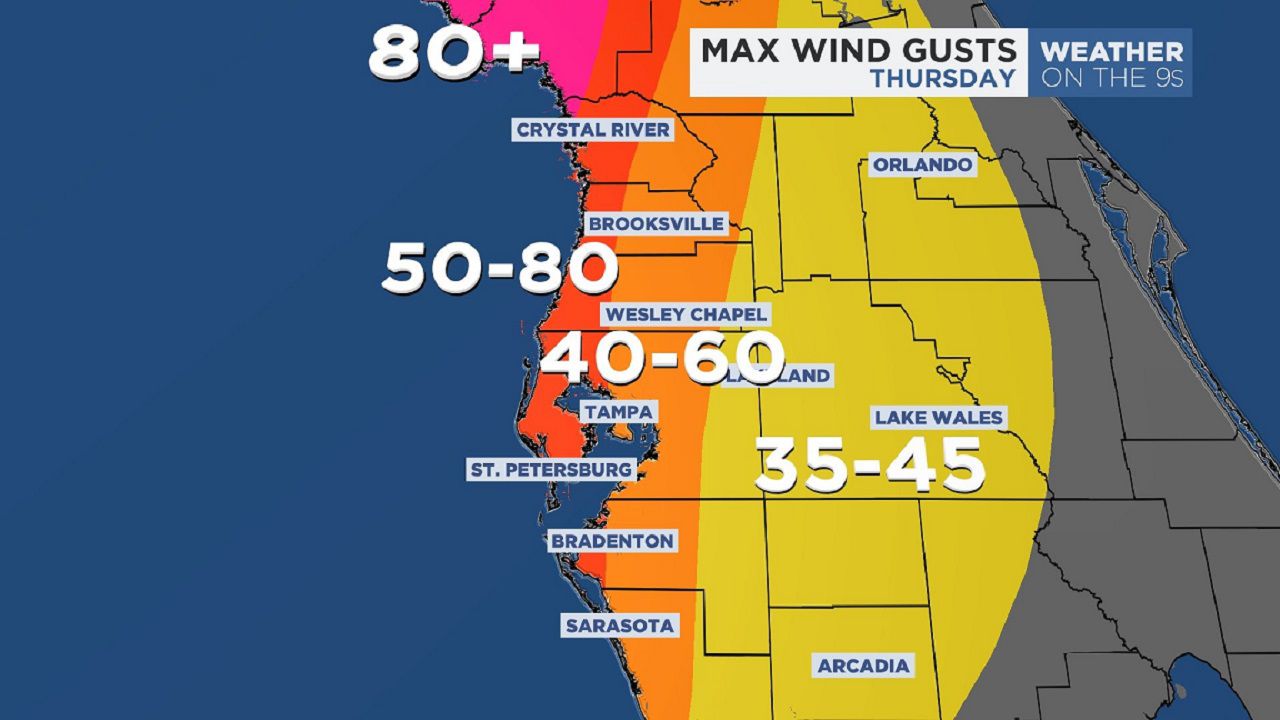
Wind gusts will be the highest along the Gulf coastal counties and around Tampa Bay this evening when the storm is at our latitude.
Wind gusts of 60-80 mph in those areas and 40-60 mph in inland spots. Wind gusts are expected to be higher in the Nature Coast later today through tonight.
There is a threat of tornadoes beginning this morning. That threat will continue into tonight.
Helene is a very large hurricane, particularly on the east side. Tropical storm force winds will continue to cover much of Florida. Wind gusts to tropical storm force have recently been reported in South Florida and the Keys in the last hour.
The fast forward speed when Helene moves inland will result in a far inland penetration of strong winds over parts of the southeastern United States.

For maximum wind gusts, we are forecasting 60-80 mph along the coast, 50-70 mph for Tampa Bay. Inland 40-50 mph and 30-45 mph further inland over Polk County.
Tornadoes are possible Thursday, especially across the Nature Coast and Tampa Bay area.
Landfall is expected in the Big Bend between 8 p.m. and 10 p.m. Thursday night.
A Flood Watch is in place through Friday morning across the area for the possibility of 3 to 6 inches of rain the next few days.
There will be far reaching impacts across the Southeastern U.S. the next few days due to how broad this storm is.
Because of that fast forward speed strong winds will spread very far inland, all the way into central and northern Georgia.
There will be flooding and wind damage through many areas of Georgia.
Flooding and wind damage to trees will be a concern all the way up into the western Carolinas and southern Appalachians.
There’s a risk of large scale flooding with landslides in the mountains Friday into the weekend.
Expect on and off outer rain bands from Helene through Thursday with the heaviest rains likely over the Gulf and along the coast.
Conditions will improve late Thursday night after midnight into Friday morning. Surge should start slowly coming down or leveling off after the midnight high tide on the Nature Coast.
Impacts will be largest for those living in flood-prone areas near the coast and those who live in non-well-built homes.
However, impacts will be less significant for those who live in well-built homes outside of flood zones.
Storm surge
Storm surge will be the biggest impact from the storm.
At this point, it appears the highest surge potential will coincide with the evening low tide, which is around 5 p.m. to 7 p.m. for most of our area on Thursday.
The next high tide would be after midnight, but Helene would likely be weakening and pulling away from our area, so the water should be coming down by then.
For coastal Hernando and Citrus counties, expect 6 to 10 feet of surge above the mean high tide mark.
Coastal Pasco, Pinellas, and Hillsborough counties (including Tampa Bay) could see 4 to 7 feet of surge.
Coastal Manatee could see 3 to 5 feet of surge.
The lower number of this range is the most likely outcome, whereas the top number (i.e. 10 ft for Nature coast & 7 ft for Tampa Bay) is the worst-case scenario and much less likely to pan out.
So it is more likely for the lower end of the surge forecast to verify than the upper end.
To put this in perspective, the coastal flooding could be very similar to what happened during Idalia last year.
No storms are exactly alike, so it could be a bit lower or a bit higher, but Idalia may be a good approximation for this storm.
Rainfall
Since Helene will be a quick moving storm, rainfall will not be incredibly high.
However, our ground is saturated and we could pick up a quick 3 to 6 inches of rain with locally higher amounts.
This could result in some localized flash flooding.
A low end tornado risk will be possible for the entire area, particularly on Thursday.
Our team of meteorologists dives deep into the science of weather and breaks down timely weather data and information. To view more weather and climate stories, check out our weather blogs section.