


TAMPA, Fla. – We continue to monitor Tropical Storms Laura and Marco. Both will likely be hurricanes over the Gulf of Mexico this week. Neither will directly affect the Tampa Bay Area.
What You Need To Know
- Tropical Storms Laura and Marco projected to be hurricanes
Laura remains over Hispanola this morning. The atmospheric conditions remain favorable for Laura to strengthen but being over land, and mountainous land will prevent that through Monday.
After exiting Haiti, Laura will make the long track either directly over Cuba, or close enough that strengthening will not occur. After that, Laura is expected to make its way into the Gulf, and conditions will be favorable for further development.
A big ridge of high pressure building over Florida will keep Laura away from our state, but the strength and westward progress of the ridge has been trending a bit farther west lately. This is important because the models have been also trending farther west with Laura.
This will do two main things. First, it will spend more time over the warm Gulf of Mexico and the ultimate landfall point may be farther west. Texas is now in play for Laura. A strengthening hurricane could be making a landfall sometime Wednesday night or Thursday morning anywhere from NE Texas to SW Louisiana.
Keep in mind that this will be about 2 days after Marco makes a southern Louisiana Landfall on Monday. More on that below.

Laura will likely cause hurricane related wind damage and a storm surge would be likely on the northeast side of the center’s landfall point. With trends farther west, there are growing concerns for Galveston, Texas.
For our area, with high pressure building in, and the lower pressure from Marco and Laura, we will keep an ESE wind in place with occasional gusty showers through Tuesday.
SUMMARY OF 5 AM FOR TROPICAL STORM LAURA
----------------------------------------------
LOCATION...18.8N 70.9W
ABOUT 95 MI E OF PORT AU PRINCE HAITI
ABOUT 110 MI SE OF CAP HAITIEN HAITI
MAXIMUM SUSTAINED WINDS...45 MPH
PRESENT MOVEMENT...WNW AT 18 MPH...30 KM/H
MINIMUM CENTRAL PRESSURE...1005 MB...29.68 INCHES
WATCHES AND WARNINGS
--------------------
CHANGES WITH THIS ADVISORY:
The government of Cuba has issued a Tropical Storm Warning for the Cuban provinces of Ciego De Avila, Sancti Spiritus, Villa Clara,
Cienfuegos, Matanzas, Mayabeque, La Habana, and Artemisa.
SUMMARY OF WATCHES AND WARNINGS IN EFFECT:
A Tropical Storm Warning is in effect for...
* The northern coast of the Dominican Republic from Cabo Engano to
the border with Haiti
* The southern coast of the Dominican Republic from Cabo Engano to
Punta Palenque
* The northern coast of Haiti from Le Mole St. Nicholas to the
border with the Dominican Republic
* The southeastern Bahamas and the Turks and Caicos Islands
* Cuban provinces of Camaguey, Las Tunas, Holguin, Guantanamo,
Santiago de Cuba, Granma, Ciego De Avila, Sancti Spiritus, Villa
Clara, Cienfuegos, Matanzas, Mayabeque, La Habana, and Artemisa
A Tropical Storm Watch is in effect for...
* The central Bahamas
* Andros Island
* Florida Keys from Ocean Reef to Key West and the Dry Tortugas
* Florida Bay
* Cuban province of Pinar Del Rio
TROPICAL Storm Marco
As for Tropical Storm Marco, it is a much smaller storm. But, now in the Gulf of Mexico traveling north Northwestward on the westward extent of the ridge of high pressure that is over Florida. So, it will stay at a safe distance from the West Coast of Florida.
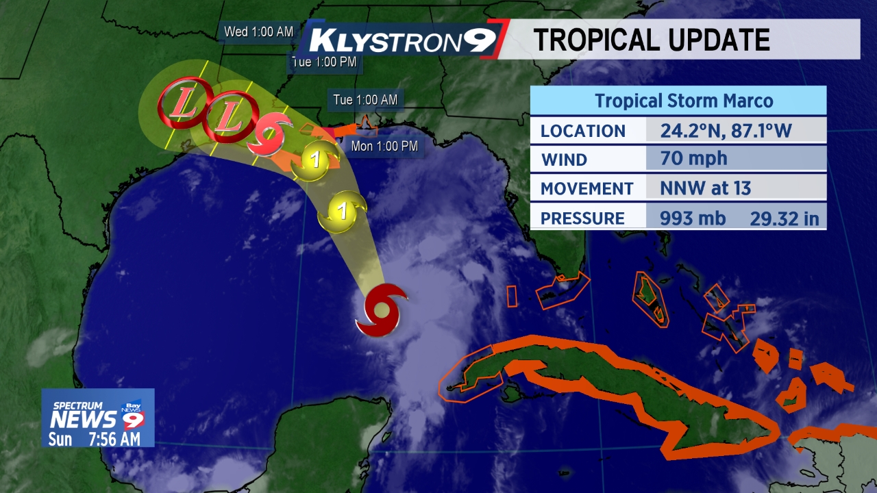
Strengthening is expected and Marco will likely make a landfall somewhere along the SW or Southern Louisiana Coast on Monday as a hurricane. As a small storm, the main threat will be hurricane force wind in a small area. Storm surge from Louisiana eastward to perhaps the Florida, Alabama border is also expected.
SUMMARY OF 5 am
----------------------------------------------
LOCATION...23.7N 87.0W
ABOUT 185 MI NW OF THE WESTERN TIP OF CUBA
ABOUT 395 MI...635 M SSE OF THE MOUTH OF THE MISSISSIPPI RIVER
MAXIMUM SUSTAINED WINDS...70 MPH
PRESENT MOVEMENT...NNW AT 13 MPH...20 KM/H
MINIMUM CENTRAL PRESSURE...994 MB...29.36 INCHES
WATCHES AND WARNINGS
--------------------
CHANGES WITH THIS ADVISORY:
A Storm Surge Warning has been issued from Morgan City Louisiana to Ocean Springs Mississippi.
A Hurricane Warning has been issued for the coast of Louisiana from Morgan City to the Mouth of the Pearl River.
A Tropical Storm Warning has been issued for Louisiana for Lake Pontchartrain, Lake Maurepas, and Metropolitan New Orleans
The Hurricane Watch from the Mouth of the Pearl River to the Mississippi/Alabama border has been changed to a Tropical Storm
Warning.
The Tropical Storm Warning has been discontinued for the province of Pinar del Rio Cuba for Marco.
SUMMARY OF WATCHES AND WARNINGS IN EFFECT:
A Storm Surge Warning is in effect for....
* Morgan City Louisiana to Ocean Springs Mississippi
* Lake Borgne
A Hurricane Warning is in effect for...
* Morgan City Louisiana to the Mouth of the Pearl River
A Storm Surge Watch is in effect for...
* Sabine Pass to Morgan City Louisiana
* Ocean Springs to the Alabama/Florida border
* Lake Pontchartrain, Lake Maurepas, and Mobile Bay
A Hurricane Watch is in effect for...
* Intracoastal City Louisiana to west of Morgan City
* Lake Pontchartrain, Lake Maurepas, and Metropolitan New Orleans
A Tropical Storm Warning is in effect for...
* Mouth of the Pearl River to the Mississippi/Alabama border
* Lake Pontchartrain, Lake Maurepas, and Metropolitan New Orleans
A Tropical Storm Watch is in effect for...
* Mississippi/Alabama border to the Alabama/Florida border