Our Spectrum Bay News 9 Weather Experts have broken down, by county, what to watch for as Milton gets closer to landfall.
For the latest forecast updates, you can check here.
Hurricane Warning (Peak Winds: until Noon Thursday)
Winds: 75 mph, gusts to 90
Flood Warnings for Withlacoochee River At US 41 Dunnellon affecting Levy and Citrus counties and Withlacoochee At SR 200 Holder affecting Citrus County.
Flood Watch through Thursday evening.Rainfall: 5-10 inches, locally higher amounts possible
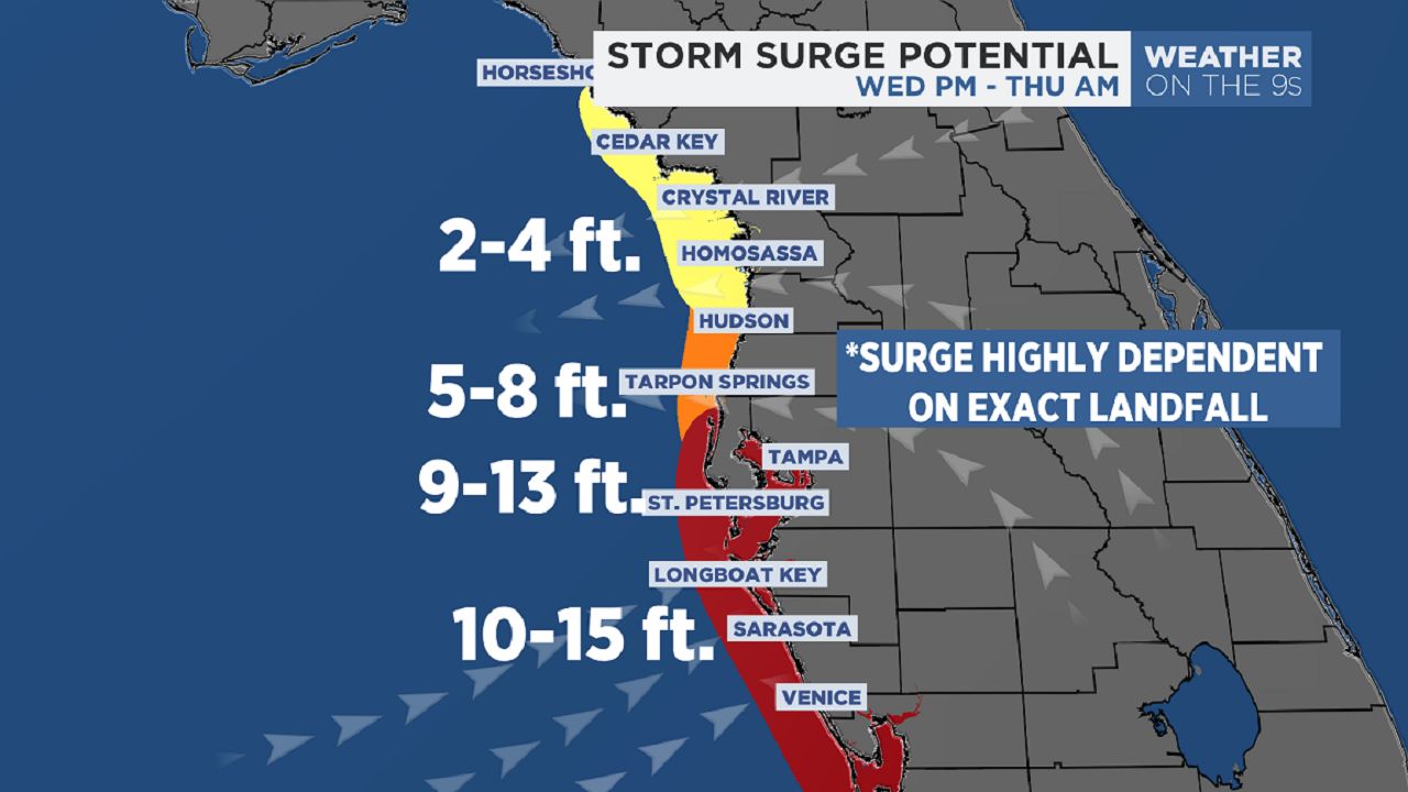
Storm Surge Warning
Surge is not likely if it makes landfall south of Citrus County.
Hurricane Warning Winds: 75 mph, gusts to 90
Flood Warning for Withlacoochee River At US 301 Trilby affecting Pasco and Hernando counties.
Flood Watch through Thursday evening.
Rainfall: 5-10 inches, locally higher amounts possible
Storm Surge Warning
Surge is not likely if it hits south of the county.
Hurricane Warning (Peak Winds: until midday Thursday)
Winds: 80 mph, gusts to 100
Flood Warning for Withlacoochee River At US 301 Trilby affecting Pasco and Hernando counties and Anclote River At Elfers at Little Road affecting Pasco County.
Flood Watch through Thursday evening.
Rainfall: 5-10 inches, locally higher amounts possible
Storm Surge Warning
The potential for up to 3-7 feet above ground somewhere within surge prone areas if the storm makes landfall north of Pasco County, surge is not likely if it hits south.
Hurricane Warning (Peak Winds: until midday Thursday)
Winds: 80 mph, gusts to 110
Flood Watch through Thursday evening.
Rainfall: 5-10 inches, locally higher amounts possible
Storm Surge Warning
The potential for up to 4-9 feet above ground somewhere within surge prone areas if the storm makes landfall in the county or north, surge is will be lower if it hits south of Tampa Bay.
Hurricane Warning (Peak Winds: until midday Thursday)
Winds: 70 mph, gusts to 100
River Flood Warning for Hillsborough River At Morris Bridge affecting Hillsborough County.
FLOOD WARNING NOW IN EFFECT FROM WEDNESDAY EVENING UNTIL FURTHER NOTICE for the Hillsborough River near Hillsborough River State Park. Major flooding is forecast. This approaches the flood of record. Bankfull stage is 8.0 feet. The river is expected to rise above flood stage late tomorrow evening and continue rising to 15.8 feet Friday morning.
Flood Watch through Thursday evening.
Rainfall: 5-10 inches, locally higher amounts possible
Storm Surge Warning
The potential for up to 5-10 feet above ground somewhere within surge prone areas if the storm makes landfall in the county or north, surge will be lower if it hits south of Tampa Bay.
Hurricane Warning (Peak Winds: until noon Thursday)
Winds: 75 mph, gusts to 100
Flood Watch through Thursday evening.
Major flooding is forecast on the Manatee River near Myakka Head at SR 64 Until further notice. Bankfull stage is 7.0 feet. The river is expected to rise above flood stage early tomorrow afternoon and continue rising to a crest of 17.0 feet early Thursday afternoon. Flood stage is 11.0 feet.
Rainfall: 3-8 inches, locally higher amounts possible
Storm Surge Warning
The potential for up to 8-12 feet above ground somewhere within surge prone areas.
Hurricane Warning (Peak Winds: until Thursday afternoon)
Winds: 60 mph, gusts to 85
Flood Watch through Thursday evening.
Rainfall: 4-9 inches, locally higher amounts possible
Our team of meteorologists dives deep into the science of weather and breaks down timely weather data and information. To view more weather and climate stories, check out our weather blogs section.